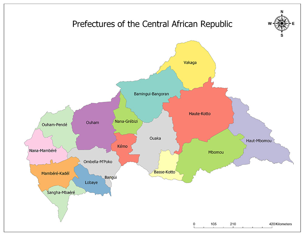
This article describes the seventeen prefectures or the regions of the Central Africa Republic, their population and capital city.
The Central African Republic state, which is located in the center of the African continent, is divided into 17 administrative regions.
14 of these administrative regions have regional status, 2 of them are commercial districts and one of them is the autonomous city.
Read: POLITICAL HISTORY OF THE CENTRAL AFRICAN REPUBLIC
Regarding administrative and cultural conditions, the regions which are formed by considering administrative and cultural conditions are also divided into 71 districts in total.
SEVENTEEN PREFECTURES OF THE CENTRAL AFRICAN REPUBLIC
The Central African Republic is divided into seventeen administrative regions under the name of prefectures.
These administrative divisions of the Central African Republic are: Bangui, Mbomou, Basse-Kotto, Kémo, Nana-Mambéré, Ouham, Sangha-Mbaéré, Lobaye, Ombella-M’Poko, Ouham-Pendé, Haut-Mbomou, Ouaka, Haute-Kotto, Bamingui-Bangoran, Vakaga, Nana-Grébizi, and Mambéré-Kadéï.

BANGUI
Bangui is the largest city and capital of the Central African Republic. The city is located on the banks of the Ubangi River. The majority of the country’s population lives in the capital city Bangui and nearby cities.
The city of Bangui has an autonomous government. Although it is the smallest city in the Central African Republic with an area of 67 square kilometers, it is the most populous city with a population of over 747,109 according to 2013 estimates.
MBOMOU
Mbomou is one of the 17 regions of the Central African Republic. Mbomou region is the second largest region in the country with its surface area of 61,150 square kilometers and it is one of the middle-density regions of the country with its population of 164,008.
The region is located in the northern part of the country and is adjacent to Haut-Mbomou in the east, Haute-Kotto in the north, Basse-Kotto in the west and the Democratic Republic of the Congo in the south. The administrative capital of the region is Bangassou. The region is also divided into four districts.
BASSE-KOTTO
Basse-Kotto is one of the 17 regions of the Central African Republic. The population of the region is 249,150 according to 2003 data. The area is 17,604 square kilometers. Mobaye is the capital of the region.
KÉMO
Kémo is one of the 17 regions of the Central African Republic. With an area of 17,204 square kilometers, Kémo is one of the smallest in the country, with 118,420 inhabitants and one of the least densely populated regions of the country.
The region is located in the central region of the country, north of Nana-Grébizi, east of Ouaka, Ouham, and Ombella-Mpoko in the west, and the Democratic Republic of the Congo in the south. Sibut is the administrative capital of the region. The region is also divided into three districts.
NANA-MAMBÉRÉ
Nana-Mambéré is one of the 17 regions of the Central African Republic. The Nana-Mambéré region is one of the medium-sized regions of the country both in terms of its surface area and population.
The region is located in the central region of the country, Ouham-Pendé in the north, Ombella-Mpoko in the east, Mambéré-Kadéï in the south and Cameroon in the west. Bouar is the administrative capital of the region.
The region is also divided into three districts. According to the official data of 2003, 233,666 people live in the region. With an area of 26,600 square kilometers, the region is one of the smallest regions of the country.
OUHAM
Ouham is one of the 17 regions of the Central African Republic. The Ouham region is the fifth of the country in terms of area and the third most densely populated region in the country.
The region is located in the western part of the country. It is neighbor to Nana-Grébizi and Kémo in the east, Ouham-Pendé in the west, Ombella-Mpoko in the south and Chad in the north. The capital is Bossangoa. The region is also divided into five districts.
According to the official data of 2003, 369,220 people live in the region. The region is one of the smallest regions of the country with its 50,250 square kilometers of face measurement.
SANGHA-MBAÉRÉ
Sangha-Mbaéré is one of the 17 regions of the Central African Republic. The region is one of the two trade regions within the country. The Sangha-Mbaéré region is one of the smallest areas of the country both in terms of area and population density.
The region is located in the southwestern part of the country and is adjacent to Mambéré-Kadéï to the north, Lobaye to the northeast, the Congo Republic to the southeast and Cameroon to the west. The administrative capital of the region is Nola. The region is also divided into two districts. According to the official data of 2003, 101,074 people live in the region. The region is one of the smallest regions of the country with a surface area of 19,412 square kilometers.
LOBAYE
Lobaye is one of the 17 regions of the Central African Republic. The region has a surface area of 19,235 square kilometers. The population of Lobaye is 246,875 according to 2003 data. The administrative center of the region is Mbaïki.
OMBELLA-M’POKO
Ombella-Mpoko is one of the 17 regions of the Central African Republic. The region of Ombella-Mpoko is one of the medium-sized regions of the country in terms of area and it is the fifth largest density region of the country in terms of population.
The region is located in the western part of the country. It is neighbor to Ouham in the north, Kémo in the northeast, Lobaye and Mambéré-Kadéï in the southwest, Nana-Mambéré in the west, Ouham-Pendé in the northwest and the Democratic Republic of the Congo in the south.
Bimbo is the administrative capital of the region. The region is also divided into four districts. According to the official data of 2003, 356,725 people live in the region. The region is one of the small-scale regions of the country with a surface area of 31,835 square kilometers.
OUHAM-PENDÉ
Ouham-Pendé is one of the 17 regions of the Central African Republic. The administrative capital of the region is Bozoum. The area is 32,100 square kilometers and according to 2003 data the population is 430,506.
HAUT-MBOMOU
Haut-Mbomou is one of the 17 regions of the Central African Republic. The Haut-Mbomou region is the fourth-largest country in the country. The region is located in the most eastern part of the country and is adjacent to Haute-Kotto and Mbomou to the west and South Sudan to the east.
The administrative capital of the region is Obo. The region is also divided into three districts. According to the official data of 2003, 57,602 people live in the region. The region is the third-largest region in the country with its 55,530 square kilometers.
OUAKA
Ouaka is one of the 17 regions of the Central African Republic. The Ouaka region is the sixth largest country in terms of area and population. The region is located in the central region of the country.
It is neighbor to Bamingui-Bangoran north, Haute-Kotto in the northeast, Basse-Kotto in the southeast, Nana-Grébizi and Kémo in the west and the Democratic Republic of the Congo in the south. The administrative capital of the region is Bambari.
The region is also divided into five districts. According to the official data of 2003, 276,710 people live in the region. The region is the sixth-largest region of the country, with an area of 49,900 square kilometers.
HAUTE-KOTTO
Haute-Kotto is one of the 17 regions of the Central African Republic. The Haute-Kotto region is the largest in the country in terms of area and is one of the least populated regions of the country in terms of population.
The region is located in the northeastern part of the country, in the north there is Vakaga, in the southeast, Haut-Mbomou in the south, Mbomou, Basse-Kotto, and Ouaka in the southwest, Bamingui-Bangoran in the west, Sudan and South Sudan in the northeast. The administrative capital of the region is Bria. The region is also divided into three districts. According to the official data of 2003, 90,316 people live in the region. The region is the largest region of the country with a surface area of 86,650 square kilometers.
BAMINGUI-BANGORAN
Bamingui-Bangoran is one of the 17 regions of the Central African Republic. The Bamingui-Bangoran region is the third largest country in terms of area and is the country’s least densely populated region.
The region is located in the north of the country. It is neighbor to Vakaga in the northeast, Haute-Kotto in the southeast, Ouaka in the south, Nana-Grébizi in the southwest and Chad in the north. The administrative capital of the region is Ndélé. The region is also divided into two districts. According to the official data of 2003, 43,229 people live in the region. The region is the third largest region of the country with an area of 58,200 square kilometers.
VAKAGA
Vakaga is one of the 17 regions of the Central African Republic. Vakaga is one of the medium-sized regions of the country in terms of surface area and it is the second region with the least population in terms of population. The region is located in the northernmost part of the country and is adjacent to Bamingui-Bangoran in the southwest, Haute-Kotto in the east, Chad in the northwest and Sudan in the northeast. The administrative capital of the region is Birao. The region is also divided into two districts. According to the official data of 2003, 52,255 people live in the region. The region is the third largest region of the country with an area of 46,500 square kilometers.
NANA-GRÉBIZI
Nana-Grébizi is one of the 17 regions of the Central African Republic. The region is one of the two trade regions within the country. The region is located in the central part of the country. It is neighbor to Ouaham in the west, Bamingui-Bangoran in the northeast, Ouaka in the southeast and Kémo in the south. Kaga-Bandoro is the administrative capital of the region. The region is also divided into two districts. According to the official data of 2003, 117,816 people live in the region. The region is one of the medium-sized areas of the country with a surface area of 19,996 square kilometers.
MAMBÉRÉ-KADÉÏ
Mambéré-Kadéï is one of the 17 regions of the Central African Republic. The region has a surface area of 30,203 square kilometers and the population of the region is 364,795 according to 2003 data. The administrative center of Mambéré-Kadéï is Berbérati.


