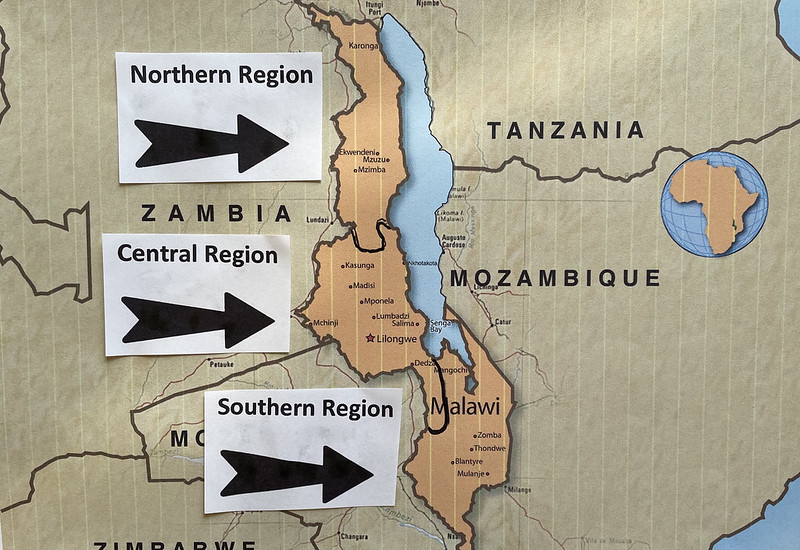
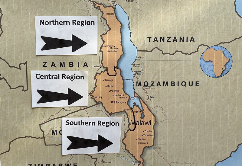
This post discusses the regions of Malawi; the variety that Malawi is famed for is reflected both between these regions and within each one.
Malawi is divided into three regions and subdivided into 28 districts. Malawi Regions (province capitals in parenthesis): The Northern Region (Mzuzu), the Central Region (Lilongwe), and the Southern Region (Blantyre).
An area of some 118,000 square kilometres (46,000 square miles) (one fifth is Lake Malawi) makes Malawi one of the smallest countries in this region of Africa. Its neighbor, Zambia, is six times the size. Malawi is similar in size to Cuba; less than half that of the United Kingdom. At approximately 900 kilometres (560 miles) long and varying widths never more than one third of its length, the country is clearly elongated north-south along the line of the Rift Valley in which Lake Malawi sits.
Read: REGIONS OF MOZAMBIQUE
This elongated shape of Malawi lends itself to a 3-way regional division: North, Central and South. The variety that Malawi is famed for is reflected both between these regions and within each one. A Malawi tour combining elements of landscape, wildlife, lake and culture can be taken in each of the regions, with each region giving a different experience.

The Regions of Malawi:
SOUTH MALAWI
The southern third of Malawi is the most populated and the most developed economically. Dominated by Blantyre and physically by the great Shire Valley and Mulanje Mountain, as well as being home to a number of National Parks and Wildlife Reserves, including the Lake Malawi National Park, there is great variety to be experienced in South Malawi.
LANDSCAPE
Snaking through the region, the Shire River (pronounced ‘Shri-ee’) drains Lake Malawi, and follows the Rift Valley southwards. The Lower Shire Valley is broad and flat as the river flows out to Mozambique in the extreme south of the country. This is the lowest point in the country, yet only just over 100km away is Malawi’s highest peak, the great Mount Mulanje which towers to over 3000 metres (9850 feet) – the highest mountain in the whole of central Africa. It is actually a massif of peaks and basins, a huge forested ‘island in the sky’ accessible only on foot. The area between Mulanje and Blantyre is dominated by tea estates. Full of beautiful scenery and great colonial character, the estates at Thyolo are easy to visit. To the west of Mulanje is the region’s other massif, Zomba Plateau. This is a table-like mountain rising to over 2080 metres (6800 feet) with sheer scarp-like edges. It’s possible to drive the top of the plateau to explore the forested interior and take in the stunning views from the edges.
WILDLIFE
South Malawi has more National Parks & Wildlife Reserves than any other region. Three of them are in the low lying Lower Shire Valley, home to vast sugar estates and accessed by descending the dramatic Thyolo Escarpment south –west of Blantyre. Majete Wildlife Reserve stretches west from the Shire River and is currently being re-stocked as a ‘Big 5’ destination. Lengwe National Park has a good variety of antelope, including the beautiful nyala, and is easy to explore on driveable tracks and using hides at waterholes. Mwabvi Wildlife Reserve is the most remote and sadly largely neglected and rarely visited. The area furthest south in the Lower Shire Valley is Elephant Marsh – notable now for its birdlife. Further north and on the upper reaches of the Shire River, is Liwonde National Park, Malawi’s premier game park, which offers boat safaris as in addition to the usual walking and 4×4 safaris.
LAKE
The last of South Malawi’s National Parks is the Lake Malawi National Park at Cape Maclear. A UNESCO World Heritage Site, the waters and fish are protected, making the Lake here a veritable aquarium of tropical fish. Between the port of Monkey Bay and the historic Mangochi is Lake Malawi’s greatest concentration of hotels and lodges, with a long line of wonderful sandy beaches backed by a variety of accommodation options. This is known as the Mangochi Lakeshore. South Malawi has two other lakes of note, Malombe, which is a broadening of the Shire River shortly after it leaves Lake Malawi, and Lake Chilwa, a wetland area of international importance.
CENTRAL MALAWI
Most international visitors to Malawi arrive at Lilongwe, the capital; hence their first view of the country is the Central Region. It gives easy access to the rest of the country, including Lake Malawi, as well as being an exciting region in its own right. Gently undulating landscapes give the area the appearance of a plain, but it is actually part of the Central African Plateau at an altitude of some 4000ft (1200m). Only in the east, close to the Lake, where the plateau’s escarpments descend into the Rift Valley, do its occasionally steep sides reveal the truth.
LANDSCAPE
The Central African Plateau is crossed by numerous rivers making their separate ways to the Lake and, here and there, isolated hills, called inselbergs, punctuate the gentle landscapes. Though not quite as high or dramatic as in other regions, Central Malawi has its fair share of highlands and forests. Dzalanyama Forest Reserve lies west of Lilongwe and is known for its birdlife. The Dedza Highlands, Dedza-Salima Forest Reserve, Thuma Forest Reserve, Dowa Highlands and Ntchisi Forest Reserve to the east of the capital stretch south-north along the edge of the Rift Valley.
WILDLIFE
North of Ntchisi is the Nkhotakota Wildlife Reserve, a genuine wilderness area of miombo woodland on the Rift Valley escarpment cut by the magnificent Bua River. Just beginning to open up, it is also home to a rich diversity of flora and fauna, including a number of large mammal species. Central Malawi’s other protected area is the Kasungu National Park. A large area of woodland, bush and grassland and once Malawi’s main National Park, poaching and general neglect have seen animal numbers reduce.
LAKE
Senga Bay is the closest point on Lake Malawi to Lilongwe, just an hour and half’s drive from the airport. It has a range of hotels & lodges overlooking lovely beaches, and a small forest reserve. It is also the place from which to gain access to the Marelli Islands, the 3 northernmost islands of the Lake Malawi National Park which are a 15 minute boat journey away. Further north, the beaches continue, though Nkhotakota is known more for its history as a centre for the slave trade whilst Dwangwa has grown as a result of the giant sugar estate here.
NORTH MALAWI
North Malawi has so much to offer the visitor. Less well known than the rest of the country and with a lower population density, it is a region for those who wish to experience Africa at its most unspoilt. Its quite astonishing beauty is the lasting memory of all who explore this unique area of central Africa.
LANDSCAPE
North Malawi is characterised by its great highlands. Forming a forested spine up from Central Malawi, the Viphya Highlands is an undulating plateau rising to 6000ft (1800m) although some peaks stretch a further 1000ft (300m) higher. On the borders with Zambia and with Tanzania, in the north, other significant ranges include the Malingu Mountains and the Misuku Hills rising to over 7000ft (2100m) and 6500ft (2000m) respectively. But the most magnificent of all is the Nyika Plateau, towering to no less than 8000ft (2500m). The rolling landscapes of the centre of the plateau are described as whalebacks but the edges of this granite core are scarp-like especially where, in the north-east, it forms the edge of the Great Rift Valley.
WILDLIFE
Not only is Nyika a unique landscape, but it is Malawi’s largest national park, populated by numerous species, including large herds of roan and eland antelope. North Malawi’s other protected area is the Vwaza Marsh Wildlife Reserve, a lower lying area offering a more traditional bush-game experience.
LAKE
The highlands of North Malawi also influence the nature of the lakeshore, which in this region can be quite dramatic – fishing villages sitting at the base of cliff-like escarpments accessible primarily by boat. Chintheche has perhaps some of the most beautiful of Lake Malawi’s beaches. Nkhata Bay is a bustling lake port, important to the fishing industry. Set back from the Northern Lakeshore at Chitimba is Livingstonia, a mission settlement high on a plateau overlooking the lake, that has a fascinating history dating back to 1894. The most northerly lakeshore town of note is Karonga, an important archaeological centre and now home to a museum that tells the history of this area back to pre-historic times. The skeletal remains of the Malawisaurus dinosaur have been unearthed nearby, as have been the oldest human remains in the country. Across the lake, into Mozambiquan waters, is Likoma Island. Not only does it have some beautiful beaches, also a missionary-built cathedral the size of Winchester’s. A nearby stretch of the Mozambique shoreline, Manda Wilderness, is a 120,000 hectare community reserve of unspoilt wilderness and white sand beaches.


